Driving Chapman's Peak
Why does Chapman's Peak Drive close so often?
It's a toll road cut into a steep, exposed cliff face between Hout Bay and Noordhoek, and the same terrain that makes it so scenic also makes it vulnerable to strong wind, heavy rain and rockfall risk — all of which prompt precautionary closures. Check the road's current status before relying on it as part of a peninsula route, and know the inland alternative in case it's shut.
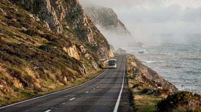
Chapman’s Peak Drive is routinely ranked among the world’s great coastal roads, a tolled route carved into the cliff face between Hout Bay and Noordhoek with the Atlantic dropping away below almost the entire way. It’s also one of the peninsula’s least predictable roads — the same dramatic geography that makes it so scenic makes it genuinely prone to closure. Here’s what to know before you build it into a peninsula day.
| Where | Connects Hout Bay and Noordhoek, on the Cape Peninsula’s Atlantic side |
| Toll | A per-vehicle fee applies; check current pricing before you go |
| Closures | Wind, heavy rain and rockfall risk all prompt precautionary shutdowns |
| Alternative route | Ou Kaapse Weg, an inland road connecting the same two towns |
| Best time | Calm mornings, and always check the live status before setting off |
What makes the drive so dramatic
Chapman’s Peak Drive threads along a near-vertical cliff face, the road cut into the rock with the Atlantic surging against the base of the cliffs far below and, in the other direction, sheer rock rising above. Regular viewpoints and pull-offs along the route let drivers stop safely to take in the scale of it, and on a clear, calm day, the combination of ocean, cliff and open sky is genuinely hard to match anywhere else on the peninsula. It’s a short drive in pure distance terms, but treating it as a fast transit route misses the point — most visitors take considerably longer than the direct driving time by stopping repeatedly along the way.
Chapman’s Peak Drive private scenic tour is a relaxed way to experience the road properly, with stops built in rather than needing to judge safe pull-offs yourself while driving.
Why it closes so often
The road’s exposed position on a steep cliff face is exactly what makes it vulnerable to closure. Strong wind is the most frequent culprit, since gusts on an exposed coastal cliff road pose a genuine risk to vehicles, particularly high-sided ones. Heavy rain adds a second risk, both through reduced visibility and increased rockfall danger on the cut cliff face above the road. Rockfall risk itself is assessed independently and can trigger a precautionary closure even without an active storm, if recent conditions have left the slope above the road unstable. None of this is unusual or a sign of poor maintenance — it’s simply the trade-off of a road built into genuinely dramatic terrain, and closures should be expected as a normal part of planning a peninsula visit rather than a rare surprise.
Chapman’s Peak e-bike tour with lunch offers a slower, closer way to experience the road when conditions allow, worth checking status for in the same way as a standard vehicle crossing.
The alternative: Ou Kaapse Weg
Whenever Chapman’s Peak Drive is closed, the standard fallback is Ou Kaapse Weg, an inland route connecting Hout Bay and Noordhoek without following the coastline. It lacks the dramatic ocean views of the coastal drive, but it’s a reliable, generally open alternative in conditions that would close the cliff road — strong wind in particular rarely affects it the same way. Knowing this route exists, and having it as a backup plan, is the single most useful piece of practical knowledge for anyone building a Cape Peninsula day around this stretch of coast.
Checking the road’s status before you go
Given how often closures happen, checking Chapman’s Peak Drive’s live operating status before setting off — rather than assuming it will be open because the weather looked fine in the City Bowl that morning — is worth the couple of minutes it takes. This matters even more if the drive is a scheduled leg of a wider Cape Peninsula loop, since a closure partway through a planned route can force a real detour if you haven’t checked in advance.
Chapman’s Peak motorcycle tour with guide is a good option for visitors wanting to experience the road on two wheels, with a guide who’ll already be tracking the day’s conditions and closures.
The toll, and what it’s for
Chapman’s Peak Drive operates as a tolled road, with a per-vehicle fee applying at a toll point along the route. The toll funds ongoing maintenance of a road that requires genuinely significant, continuous upkeep given its exposure to weather and rockfall — check current pricing directly with the road operator rather than relying on a fixed figure quoted elsewhere, since tolls are reviewed periodically.
Seeing it from above
For a genuinely different perspective on the same stretch of coastline, a helicopter flight over Chapman’s Peak and the surrounding cliffs shows the scale of the terrain in a way that’s hard to appreciate from the road itself, however dramatic the drive is at ground level.
Chapman’s Peak helicopter flight covers that aerial view, a memorable add-on for visitors who want to see the cliffs and coastline from a completely different vantage point.
Driving it safely
Beyond checking the road’s status before you go, a few habits make the drive itself more comfortable. Keep a steady, unhurried pace rather than rushing between viewpoints — the road’s curves and drop-offs reward a measured speed more than an urgent one, and there’s no genuine time pressure once you’re actually on the route. Use the marked viewpoints rather than stopping on the road itself, even briefly, since there’s little room for a stopped vehicle on most of the drive’s tighter sections.
If you’re driving in the late afternoon, be aware that low sun can create genuine glare on sections facing west, particularly heading north back toward Hout Bay, so sunglasses and a clean windscreen are worth having ready. And if wind is picking up while you’re already on the road, there’s no shame in pulling into the next safe viewpoint and waiting a few minutes to see whether it settles, rather than pressing on through a gusty stretch.
tours.cape-peninsula
Verified deep-linked GetYourGuide tours. Book through these links and we earn a small commission at no cost to you.
Photos show the destination, not the operator's own images.