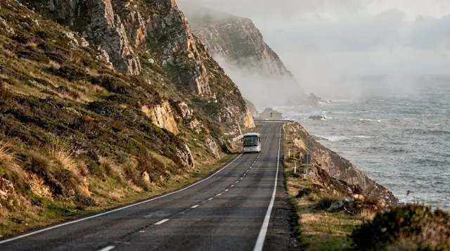
Chapman’s Peak Drive is a cliffside road carved into the mountainside between Hout Bay and Noordhoek, and it’s routinely named one of the most scenic drives in the world for good reason — the road clings to the rock face several hundred metres above the Atlantic for most of its length, with the ocean on one side and sheer cliff on the other. It’s also a toll road, and one that’s genuinely and regularly closed, not just in theory: high winds, heavy rain, and rockfall risk all shut it down, sometimes with little warning. Treat it as a highlight to build a peninsula day around, not a guaranteed leg of the trip.
| Where | Between Hout Bay and Noordhoek, Atlantic side of the peninsula |
| Length | About 9km, with several marked viewpoints and pull-offs |
| Access | Toll road — check current fees and payment options before you go |
| Closures | Wind, rain, and rockfall risk close it regularly; check status first |
| Time needed | 30-60 minutes driving; longer with photo stops |
What makes the drive itself worthwhile
The road was carved directly into the cliff face in the early twentieth century and has been reworked several times since, including safety upgrades and rockfall netting after a fatal rockslide closed it for years in the early 2000s. What you notice driving it today is how exposed it feels — narrow lanes, a rock overhang on the inland side in places, and long stretches with no barrier beyond a low wall between the road and a genuinely long drop to the water. It’s not a dangerous drive if you go at a sensible pace and don’t try to take photos while moving, but it rewards attention rather than rushing.
Private scenic tour of Chapman’s Peak DriveThe viewpoints
Several formal pull-offs along the route let you stop safely to take in the view without holding up traffic on the narrower sections — the most photographed looks back north towards Hout Bay’s harbour and the Sentinel peak, while others open out over the Atlantic itself. These are worth using rather than trying to shoot through the windscreen; the road has enough blind corners that a moving-vehicle photo stop isn’t a good trade for the shot.
For a different angle on the same road, a guided motorcycle tour or an e-bike route covers the drive at a pace that makes the exposure and the views feel considerably more immediate than from inside a car.
Chapman’s Peak motorcycle tour Chapman’s Peak e-bike tour with lunchFor the view most visitors never get, a short helicopter flight over Chapman’s Peak and the wider peninsula puts the whole shape of the coastline — the road, Hout Bay, and the mountains behind — into a single frame that’s impossible to get from the road itself.
Chapman’s Peak helicopter flightThe toll and why it exists
Chapman’s Peak Drive has operated as a toll road since it reopened after the early-2000s rockfall closure, with the toll funding the ongoing maintenance the road genuinely needs given how exposed and geologically active the cliff face is. Rates and payment methods change, so it’s worth checking the current fee at the toll booth or with your tour operator rather than relying on an old figure — this guide won’t guess at a number that’s likely to be out of date by the time you read it.
Why it closes, and what to do if it’s shut
The road sits directly beneath an unstable cliff face, and management closes it proactively rather than waiting for an incident — strong south-easter winds (the same “Cape Doctor” that clears Table Mountain’s cloud) can make driving genuinely hazardous on the exposed sections, heavy rain raises rockfall risk, and after any significant fall the road stays shut until it’s cleared and inspected. If it’s closed when you’d planned to drive it, the alternative route over Ou Kaapse Weg (Old Cape Road) still connects Hout Bay’s side of the peninsula to Noordhoek and the south, just without the coastal views — a reasonable backup rather than a wasted trip.
The best time of day to drive it
Morning light tends to favour the Hout-Bay-to-Noordhoek direction, catching the cliffs and the water from a good angle, while a late-afternoon drive the other way can put the sun low and directly in your eyes on some of the tighter bends — worth bearing in mind when you’re choosing which direction to tackle the road. Weekday mornings are also simply quieter than weekend afternoons, when the road becomes a popular drive for Capetonians as much as visitors, and the pull-offs at the main viewpoints can fill up.
Driving it yourself versus taking a tour
Self-driving Chapman’s Peak is straightforward if you’re comfortable with narrow mountain roads and happy to stop properly for photos rather than shooting from the driver’s seat. A guided tour removes the need to watch the road and the view at once, and most operators build in stops at the best viewpoints along with the wider Cape Point loop, so it’s a reasonable choice if this is one stop among several on a full peninsula day rather than the sole reason for the trip.
Checking the status before you go
The road’s operators publish current open/closed status and any restrictions, and it’s genuinely worth a quick check on the day rather than assuming from a previous visit or a general reputation for being open — conditions can change within hours during a storm system, and a closure notice at the toll gate after a long drive out is a frustrating way to find out. Most tour operators build this check into their planning as a matter of course, which is one more reason a guided option removes a layer of uncertainty for visitors unfamiliar with how quickly Cape weather can turn.